![](/images/other/stat-length.png)
![Trail Walking Sarroux - Saint-Julien - La Pyramide, le château Pierrefitte, les Orgues - Photo](https://media.geolcdn.com/t/1900/400/ext.pjpeg?maxdim=2&url=https%3A%2F%2Fstatic1.geolcdn.com%2Fsiteimages%2Fupload%2Ffiles%2F1553511878bg_sport_marche.png)
La Pyramide, le château Pierrefitte, les Orgues
grageot
User
![Length](/images/other/stat-length.png)
![Max alt](https://static1.geolcdn.com/siteimages/upload/files/1508320355ic_sort_altitude_max_24dp.png)
![Uphill gradient](https://static1.geolcdn.com/siteimages/upload/files/1508320355ic_sort_den_pos_24dp.png)
![Km-Effort](/images/other/stat-length.png)
![Min alt](https://static1.geolcdn.com/siteimages/upload/files/1508320355ic_sort_altitude_min_24dp.png)
![Downhill gradient](https://static1.geolcdn.com/siteimages/upload/files/1508320355ic_sort_den_neg_24dp.png)
![Boucle](https://static1.geolcdn.com/siteimages/upload/files/16400158638029165_repeat_loop_refresh_sync_direction_icon.png)
![Walking](https://static1.geolcdn.com/sitytour/trail-icons/101.png)
4h28
Difficulty : Easy
![Scan this QR Code to open this trail in the SityTrail application](https://capi.geolives.com/qq0zvz2zws4bq2lad0pu/sitytour/trails/612337/qr.png?size=200)
FREE GPS app for hiking
About
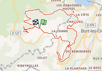
Trail Walking of 15.6 km to be discovered at New Aquitaine, Corrèze, Sarroux - Saint-Julien. This trail is proposed by grageot.
Description
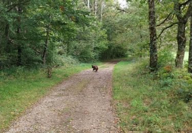
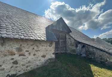
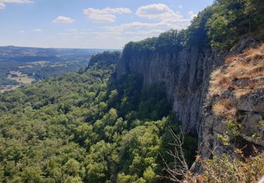
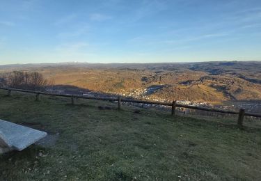
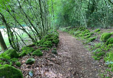
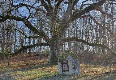
Parking devant le départ de la piste Pyramide. Aller à la table d'orientation mais aussi jusqu'aux antennes (à travers bois facile). Passer le portail du chateau première piste à droite devant la maison. Au pied des falaises pour les courageux montée jusqu'aux pieds des falaises à travers les éboulis : de vagues traces, sportif mais sans grande difficulté. Sinon rester sur le chemin balisé bleu jusqu'à la route
Positioning
Comments
Trails nearby
![Trail Walking Sarroux - Saint-Julien - Un air de montagne - Sarroux - Photo](https://media.geolcdn.com/t/375/260/ext.jpg?maxdim=2&url=https%3A%2F%2Fservices.sitytrail.com%2FGeolivesWS%2FDownloadMedia.ashx%3FTrailID%3D318091%26Media%3D17549_2.jpg)
![Walking Walking](https://static1.geolcdn.com/sitytour/trail-icons/101.png)
Walking
![](/images/other/stat-length.png)
![](https://static1.geolcdn.com/siteimages/upload/files/16400158638029165_repeat_loop_refresh_sync_direction_icon.png)
![Trail Walking Bort-les-Orgues - Barrage de Bort les Orgues - Château de Val - Photo](https://media.geolcdn.com/t/375/260/ceb2f8d3-91c1-4a2f-8fc2-e247a053be58.jpg&format=jpg&maxdim=2)
![Walking Walking](https://static1.geolcdn.com/sitytour/trail-icons/101.png)
Walking
![](/images/other/stat-length.png)
![](https://static1.geolcdn.com/siteimages/upload/files/16400158638029165_repeat_loop_refresh_sync_direction_icon.png)
![Trail Walking Bort-les-Orgues - Chute de la Saule - Photo](https://media.geolcdn.com/t/375/260/26b2b305-785d-4ba0-a6d1-6dcfb6b2c938.jpg&format=jpg&maxdim=2)
![Walking Walking](https://static1.geolcdn.com/sitytour/trail-icons/101.png)
Walking
![](/images/other/stat-length.png)
![](https://static1.geolcdn.com/siteimages/upload/files/16400158638029165_repeat_loop_refresh_sync_direction_icon.png)
![Trail Walking Bort-les-Orgues - Tour des orgues à Bort les Orgues - Photo](https://media.geolcdn.com/t/375/260/5b1c5c81-36dc-41c4-864c-ecbcff7d2e43.jpg&format=jpg&maxdim=2)
![Walking Walking](https://static1.geolcdn.com/sitytour/trail-icons/101.png)
Walking
![](/images/other/stat-length.png)
![](https://static1.geolcdn.com/siteimages/upload/files/16400158638029165_repeat_loop_refresh_sync_direction_icon.png)
![Trail sport Lanobre - Bort les orgues depuis château de val - Photo](https://media.geolcdn.com/t/375/260/789ded6b-5d89-4af9-9bec-9d11b10c52be.jpg&format=jpg&maxdim=2)
sport
![](/images/other/stat-length.png)
![](https://static1.geolcdn.com/siteimages/upload/files/16400158638029165_repeat_loop_refresh_sync_direction_icon.png)
![Trail Walking Bort-les-Orgues - Les Orgues de Bort-les-Orgues - Photo](https://media.geolcdn.com/t/375/260/deea3cfa-68bd-4e26-9fbe-312852eaa095.jpg&format=jpg&maxdim=2)
![Walking Walking](https://static1.geolcdn.com/sitytour/trail-icons/101.png)
Walking
![](/images/other/stat-length.png)
![](https://static1.geolcdn.com/siteimages/upload/files/16400158638029165_repeat_loop_refresh_sync_direction_icon.png)
![Trail Walking Bort-les-Orgues - Les Orgues de Bort Les O. - Photo](https://media.geolcdn.com/t/375/260/0a5e481c-a64a-4225-ac0e-0a1a4f276c56.jpg&format=jpg&maxdim=2)
![Walking Walking](https://static1.geolcdn.com/sitytour/trail-icons/101.png)
Walking
![](/images/other/stat-length.png)
![](https://static1.geolcdn.com/siteimages/upload/files/16400158638029165_repeat_loop_refresh_sync_direction_icon.png)
![Trail Walking Bort-les-Orgues - Les Orgues - Photo](https://media.geolcdn.com/t/375/260/de45ad4a-de77-4e58-a4e0-285397248ea6.jpg&format=jpg&maxdim=2)
![Walking Walking](https://static1.geolcdn.com/sitytour/trail-icons/101.png)
Walking
![](/images/other/stat-length.png)
![](https://static1.geolcdn.com/siteimages/upload/files/16400158638029165_repeat_loop_refresh_sync_direction_icon.png)
![Trail Walking Sarroux - Saint-Julien - le site de Saint-Nazaire - Photo](https://media.geolcdn.com/t/375/260/5f0b677a-852b-4fdc-8074-c6913b286b71.jpg&format=jpg&maxdim=2)
![Walking Walking](https://static1.geolcdn.com/sitytour/trail-icons/101.png)
Walking
![](/images/other/stat-length.png)
![](https://static1.geolcdn.com/siteimages/upload/files/16400158638029165_repeat_loop_refresh_sync_direction_icon.png)